[ 2006 | 2007 | 2008 | 2009 | 2010 | 2011 | 2012 | 2013 | 2014 | 2015 | 2016 | 2017 | 2018 | 2019 | 2020 | 2021 | 2022 | 2023 | 2024 ]
2006 Shelfwide Cruise: July 20 - July 28
The Issue. The scientific work for the commonly name Dead Zone' is hypoxia or low oxygen. The second largest zone of hypoxia in the world's coastal waters is found int eh Gulf of Mexico adjacent to the Mississippi River system. Important commercial and recreational fisheries are impacted as reduced oxygen levels force fish, shrimp and crabs from the area. Animals that cannot move away die. Freshwater and nutrients from the Mississippi lead to the annual formation of the hypoxic waters, and increasing nutrient loads beginning in the 1950s are responsible for the worsening oxygen conditions since then.

Press Release
PRESS RELEASE, JULY 28, 2006
LOUISIANA UNIVERSITIES MARINE CONSORTIUM (LUMCON)
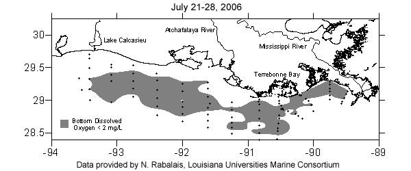
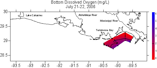
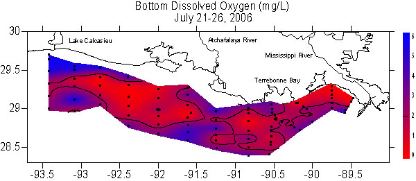
The coast wide extent of the Louisiana “Dead Zone” mapped this week is 17,280 square kilometers (or 6,662 square miles), similar to the size of Connecticut and Rhode Island combined, reported Dr. Nancy Rabalais, Chief Scientist for Northern Gulf of Mexico Hypoxia Studies. The low oxygen waters extended from near the Mississippi River to the Louisiana/Texas border. The long-term average since mapping began in 1985, and which increased with this year’s measurement, is 13,000 square kilometers (or 5,000 square miles). The goal to reach a 5,000 square kilometers size (about 2,500 square miles) as stated in the “Action Plan for Reducing, Mitigating, and Controlling Hypoxia in the Northern Gulf of Mexico” remains far off.
The scientific word for the commonly named Dead Zone is ‘hypoxia,’ or low oxygen, which results in the failure to capture fish, shrimp, and crabs in bottom-dragging trawls when the oxygen falls below the critical level of 2 ppm. Higher in the water column and on both inshore and offshore sides of the hypoxic area, there is sufficient oxygen to support sizeable numbers of fish.
The seasonal formation and persistence of hypoxia are influenced by the discharges and nutrient loads of the Mississippi and Atchafalaya rivers. The seasonally warmed, fresher river-source water forms a layer above the deeper, cooler and saltier Gulf waters, and prevents oxygen from reaching to the bottom. Nitrogen and phosphorus from the river stimulate the growth of microscopic plants, the phytoplankton. The phytoplankton are either transferred into the food web or end up as organic debris that falls to the sea floor. Decomposition of the organic debris by bacteria depletes oxygen in the lower waters.
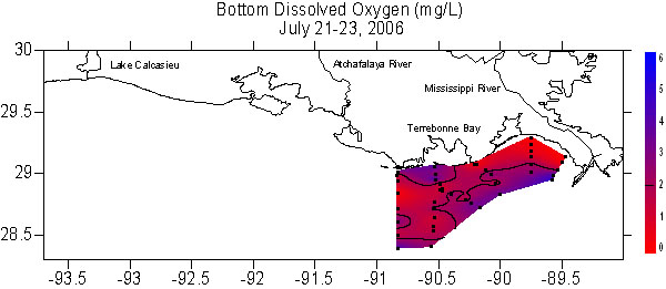
Lower than average flow of the Mississippi River in 2006 was expected to result in a smaller hypoxic zone this year. A predictive model by Gene Turner of Louisiana State University and his colleagues, however, estimated conservatively that this year’s hypoxic area would be about 17,400 square kilometers or 6,700 square miles. Turner explained why his model was estimating a size much larger than most people thought would happen. The key factor for predicting a larger hypoxic zone this summer was that the “nitrate loading this May, a critical month influencing the size of the area, is higher than last year, despite the lower river flow" said Turner, “His estimate was right on the mark” said Rabalais.
The prelude to this summer’s large size was documented by the National Oceanic and Atmospheric Administration, National Marine Fisheries Service SEAMAP ground fish surveys in June – early July. NOAA scientists on that cruise found large but patchy areas of bottom-water hypoxia along the Louisiana coast. Dr. Rabalais and her colleagues, who measure oxygen conditions along a line of stations offshore of Terrebonne Bay, have been watching the hypoxia start to develop several times this spring through early June, but then it expanded over a large area with extremely low oxygen conditions in early July.
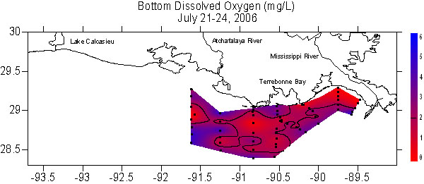
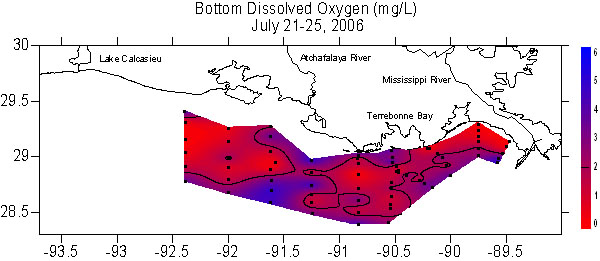
No hurricanes preceded this summer’s mapping cruise as in 2005 when the Dead Zone was smaller than predicted. Instead feeder bands from a tropical low system in the southwestern Gulf of Mexico raised winds to 30 knots and seas to 10 feet while the mapping was underway. Sustained high winds and seas usually mix up the water column and re-oxygenate the bottom waters. Indications that this was happening increased with transit farther south offshore and to the west. The result was a much thinner layer of low oxygen water near the bottom towards the end of the cruise on the western edge than when the mapping off the Atchafalaya River began.
The scientific party that mapped this year’s zone was from LUMCON, LSU, and Centenary College, and was funded by NOAA’s Center for Sponsored Coastal Ocean Research. Two scientists from the Harvard School of Public Health were onboard to study the distribution and processing of mercury in bottom mud, water, plankton and animals in the area of hypoxia. Their research is funded by NOAA’s Human Health Initiative.
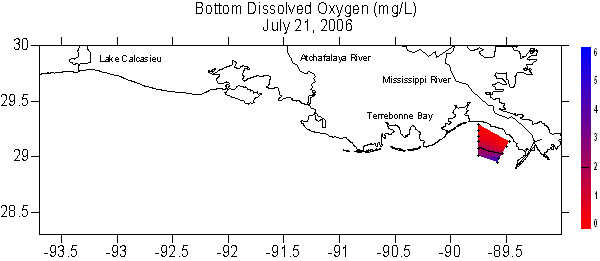
The mapping was conducted from July 21-27 from aboard the research vessel, Pelican, a vessel that is owned and operated by LUMCON and is part of the National Science Foundation’s oceanographic fleet.
Check for events of this year’s cruise at shelfwide06
For further information contact Dr. Nancy Rabalais, LUMCON, 985-851-2801, 985-870-4203 cell, nrabalais@lumcon.edu