[ 2006 | 2007 | 2008 | 2009 | 2010 | 2011 | 2012 | 2013 | 2014 | 2015 | 2016 | 2017 | 2018 | 2019 | 2020 | 2021 | 2022 | 2023 | 2024 | 2025 ]
2020 Shelfwide Cruise: July 25 - August 1

Hypoxia ForecastPress Release
Daily LogMississippi River Discharge
Photo GalleryMarine Forecast
Dissolved Oxygen MapsAdditional Maps
Marine Forecast
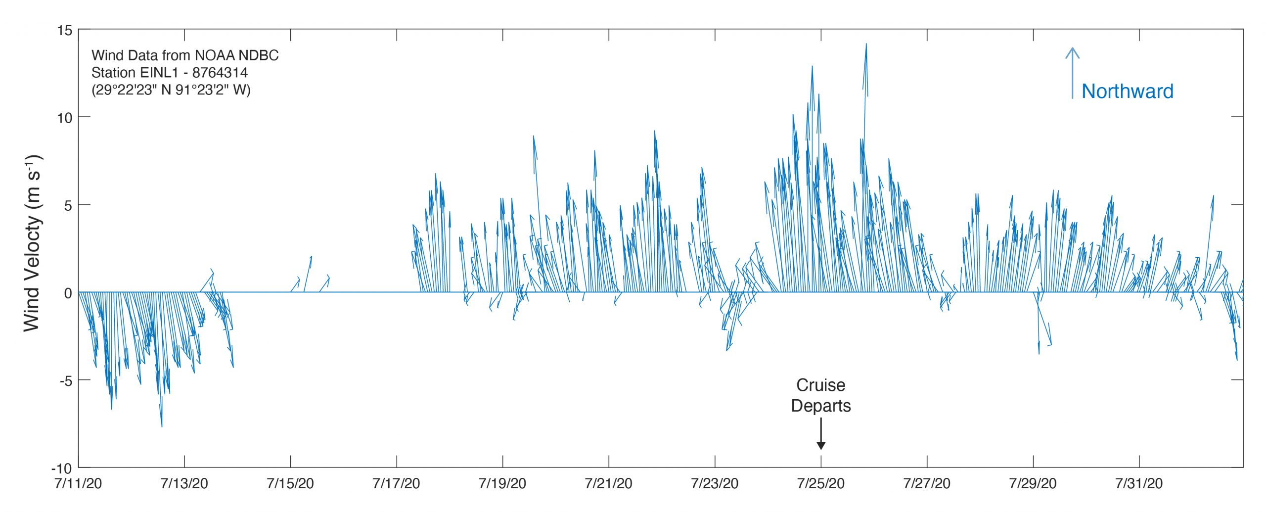
Current Marine Forecast
GMZ500-GMZ501-010415- Synopsis Pascagoula to SW Pass Mississippi- Synopsis SW Pass Mississippi River to Atchafalaya River- 1023 AM CDT Fri Jul 31 2020
.SYNOPSIS...Weak high pressure will remain over the northern Gulf of Mexico through at least Saturday. A cold front will approach the coastal waters Sunday or Monday and stall near the coast.
GMZ550-552-010415- Coastal Waters from Port Fourchon LA to Lower Atchafalaya River LA out 20 nm- Coastal waters from the Southwest Pass of the Mississippi River to Port Fourchon Louisiana out 20 mile- 1023 AM CDT Fri Jul 31 2020
REST OF TODAY Southwest winds 5 to 10 knots. Seas 1 to 2 feet. Dominant period 5 seconds.
TONIGHT Southwest winds 10 to 15 knots. Seas 1 to 2 feet. Dominant period 5 seconds.
SATURDAY West winds 5 to 10 knots. Seas 1 to 2 feet. Dominant period 5 seconds.
SATURDAY NIGHT West winds 5 to 10 knots. Seas 1 to 2 feet. Dominant period 4 seconds. Slight chance of showers and thunderstorms after midnight.
SUNDAY West winds 5 to 10 knots. Seas 1 to 2 feet. Dominant period 4 seconds. Slight chance of showers and thunderstorms.
SUNDAY NIGHT West winds 5 to 10 knots. Seas 1 foot or less. Dominant period 4 seconds.
MONDAY West winds 5 to 10 knots. Seas 1 to 2 feet. Dominant period 4 seconds.
MONDAY NIGHT West winds 5 to 10 knots. Seas 1 foot or less. Dominant period 4 seconds.
TUESDAY West winds 5 to 10 knots. Seas 1 foot or less. Dominant period 4 seconds. Slight chance of showers and thunderstorms in the afternoon.
TUESDAY NIGHT West winds 5 to 10 knots. Seas 1 foot or less. Dominant period 4 seconds. Slight chance of showers and thunderstorms.
Previous Marine Forecast
July 30, 2020 July 29, 2020 July 28, 2020 July 27, 2020 July 26, 2020