13 June 2024
New data has emerged showing that the low-oxygen “dead zone” that forms along Louisiana’s coast each summer could shrink dramatically this year — but the reason may have to do with global warming and there are conflicting findings on the question.
A forecast released this week by LSU scientists shows the dead zone could be a record low size of only 1,972 square miles. A more definitive answer will be provided when it is measured the last week of July.
However, a competing forecast issued by the National Oceanic and Atmospheric Administration estimates the dead zone at 5,827 square miles, larger than its 37-year average measured size.
The dead zone is driven by fertilizer and sewage traveling down the Mississippi River, which combine with other factors in the summer to leave the area with low oxygen, killing off some organisms and causing fish to flee.
The lower estimate released Thursday by LSU biologists Nancy Rabalais and Eugene Turner is based on a new model they developed. It combines measurements of expected levels of nutrients delivered to the Gulf by the river with the effects of Gulf water temperatures that have significantly increased over the past 20 years as a result of global warming.
 The Mississippi River watershed, which encompasses over 40% of the continental U.S and crosses 22 state boundaries, is made up of farms (yellow), cities (red), and natural lands (green). Nitrogen and phosphorus pollution in runoff and discharges from agricultural and urban areas are the major contributors to the annual summer hypoxic dead zone in the Gulf of Mexico. (Image credit: USGS)
The warmer temperatures are causing the plant and animal organisms living in the lower waters of the Gulf shelf to use up less oxygen, Turner said. Rabalais points out that algae actually creates some oxygen, too.
Turner said the warmer waters result in plant life being less efficient at photosynthesis — using sunlight to turn carbon dioxide and water into food. It also results in smaller phytoplankton and zooplankton, which in turn means they use more energy and produce less waste, all of which means less use of deep-water oxygen.
The result, they say, is that this year’s dead zone will be very close to the 2035 goal of reducing its size to only 1,900 square miles set by a federal-state task force on reducing nutrient pollution along the river.
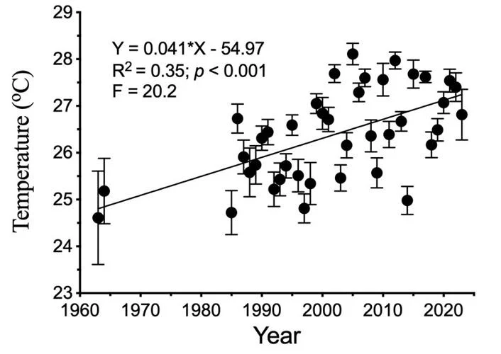 The July bottom water temperature on the continental shelf of the northern Gulf of Mexico increased at 0.41 degree Centigrade per decade from 1963 to 2023. Updated from Turner et al. (2017). (Graphic courtesy of LSU)
The NOAA estimate involves a suite of models developed over the 37 years of measuring the dead zone. They are based on how much and when nutrients enter the river basin during the year, and the amount of water flowing down the river. That prediction calls for a low-oxygen zone as big as the state of Connecticut, and more than 3,800 square miles larger than the 2035 goal.
According to the U.S. Geological Survey, in May 2024, discharge in the Mississippi and Atchafalaya rivers was about 5% above the long-term average between 1980 and 2023, and the nitrate and phosphorus loads were about 7% below and 22% above the long-term averages, respectively.
According to NOAA, exposure to low-oxygen, or hypoxic, waters has been found to alter fish diets, growth rates, reproduction, habitat use and the availability of commercially harvested species like shrimp.
The average dead zone over 37 years of summer cruises to measure it, most of which have been led by Rabalais, is 5,205 square miles.
 Area of the hypoxic zone from 1979 to 2023 and the predicted value for 2024, in square kilometers (red bar). The Hypoxia Action Plan restoration ‘goal’ is 5,000 square kilometers, or 1,900 square miles. (Graphic courtesy of LSU)
Last year’s dead zone was midway between this year’s two estimates, at 3,058 square miles. That happened during a year with an unusually low flow of water through the southernmost part of the Mississippi River during the spring and summer — low enough to allow salt water from the Gulf to move upriver, creating problems for water treatment plants in Plaquemines Parish.
That low flow was believed to have limited the amount of nutrients, and thus the size of algae blooms, in the Gulf, resulting in a smaller dead zone.
A spokesperson for NOAA said the new LSU model developed by Turner is being evaluated for future inclusion in the NOAA ensemble forecast, pending its publication in a peer-reviewed scientific journal and a review of the model’s assumptions, parameters and accuracy.
“Their use of temperature is interesting, but we will only know if it matters when the results come in,” said Don Scavia, professor emeritus at the University of Michigan School for Environment and Sustainability, who leads one of several research teams partnering with the federal government on the annual forecast. He said that until then, he and NOAA officials are sticking to the results produced by the ensemble of models it has been using.
And those results continue to point to too much fertilizer as the key problem, he said.
“The action plan to reduce the size of the Gulf of Mexico dead zone has been in place for over two decades, but each year the size of the dead zone varies around the long-term average — and this year it’s expected to be even bigger. But that long-term average is almost three times the goal set in 2001,” he said.
“Year-to-year fluctuations in the dead zone are driven primarily by weather in the Corn Belt, but the long-term trends are driven by nutrient loads from agriculture. Lack of a downward trend in the dead zone illustrates that current efforts to reduce those loads have not been effective. Clearly, the federal and state agencies and Congress continue to prioritize industrial agriculture over water quality.”
The dead zone is created by a multi-month process that includes less dense freshwater flowing out of the Mississippi and Atchafalaya rivers, which leads to a layer atop heavier salt water in the Gulf in the spring and summer.
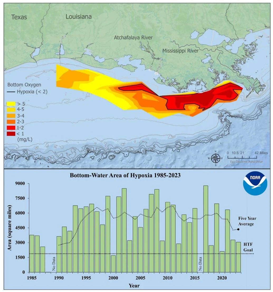 Map of measured Gulf low-oxygen hypoxia (dead zone), July 23 – July 28, 2023. Red area denotes 2 mg/L of oxygen or lower, the level which is considered hypoxic, at the bottom of the seafloor. (Bottom) Size of the hypoxic zone (green bars) measured during annual summer ship surveys since 1985, including the target reduction goal established by the Mississippi River/Gulf of Mexico Watershed Nutrient Task Force and the 5-year average measured size (black dashed lines). (LUMCON/LSU/NOAA)
Nutrients in the freshwater – mostly nitrates and phosphorus from Midwest agriculture, combined with smaller amounts from municipal sewage treatment plants and individual sewage systems – feed an explosion in the growth of algae in the upper water layer.
As the algae dies, it sinks to the Gulf bottom and decomposes, using up oxygen in the deeper salt water. When oxygen levels drop to 2 parts per million and below, it’s called hypoxia, a condition that kills bottom-living organisms, including crabs, mollusks and worms, and causes fish and other organisms to swim away.
A team of scientists led by LSU researchers will monitor oxygen levels along the Louisiana and Texas coast between July 25 and Aug. 1, with results to be released a few days later.
The forecasts and monitoring cruises help guide efforts by the federal government and states along the river to find ways to reduce the release of nutrients in the watershed. Billions of dollars in federal, state and private funds have been spent on efforts to change farming practices and on nutrient-capturing wetlands along streams and rivers, as well as on finding other ways to reduce nutrients before they exit the two rivers in the Gulf.
Much of that effort is overseen by the Interagency Mississippi River and Gulf of Mexico Hypoxia Task Force, which set the 2035 goal of reducing the size of the dead zone to a five-year average of only 1,900 square miles.