Tyler Wittkofsky | NOAA
2 August 2023
Today, NOAA-supported scientists announced that this year’s Gulf of Mexico “dead zone”— an area of low to no oxygen that can kill fish and marine life — is approximately 3,058 square miles. That’s almost two million acres of habitat potentially unavailable to fish and bottom species — nearly as large as the land area of Yellowstone National Park.
The five-year average size of the dead zone (also known as the hypoxic zone) is now 4,347 square miles, which is over two times larger than management targets. Since records began in 1985, the largest hypoxic zone measured was 8,776 square miles in 2017. This is the seventh smallest zone on record in the 37 year measurement history.
The measurement was made during an annual survey cruise, led by a team of scientists from Louisiana State University and the Louisiana Universities Marine Consortium (LUMCON) aboard the R/V Pelicanoffsite link during the last week of July. The information gathered is a key metric used by the Mississippi River/Gulf of Mexico Hypoxia Task Force to measure progress toward achieving their five-year average target of getting the dead zone to 1,900 square miles or smaller by 2035. The cruise provides a one-time snapshot of the dead zone; the five-year average captures the dynamic and changing nature of the zone over time.
“With more frequent and intense weather events in the Gulf of Mexico and elsewhere, it is imperative that we continue to measure hypoxia in this region as an indicator of ocean health and progress toward management targets,” said Nicole LeBoeuf, director of NOAA’s National Ocean Service. “The data collected from this annual, long-term research program helps decision-makers fine tune strategies to reduce the size of the hypoxic zone and mitigate harmful impacts to our coastal resources, communities and economy.”
In June, NOAA forecasted a below-average sized hypoxic zone of 4,155 square miles, based primarily on Mississippi River discharge and nutrient runoff data from the U.S. Geological Survey. The measured size of the hypoxic zone fell within the uncertainty range for the models which factors in some of the inherent environmental variability of the system such as the below average river discharge over the summer. This demonstrates the overall accuracy of the models and their ability to be applied as tools for nutrient reduction strategies.
The 2023 hypoxic area was characterized by smooth sailing and blue, blue waters” said Nancy Rabalais, Ph.D. professor at Louisiana State University and LUMCON, who is the co-principal investigator. “The discharge of the Mississippi River for July was below the long-term summer average. The usual layering of warmer, less salty water over cooler, saltier water was not as strong as during a higher Mississippi River discharge. The salinity from the Mississippi River to the Atchafalaya River transitioned from around 30 psu (practical salinity units) at the surface to 36 psu at the bottom, maintaining strong stratification and resulting in low bottom-water dissolved oxygen. The differences on the western portion of the study area were weaker, with a difference from 34 psu at the surface to 36 psu at the bottom, with no hypoxic bottom water.”
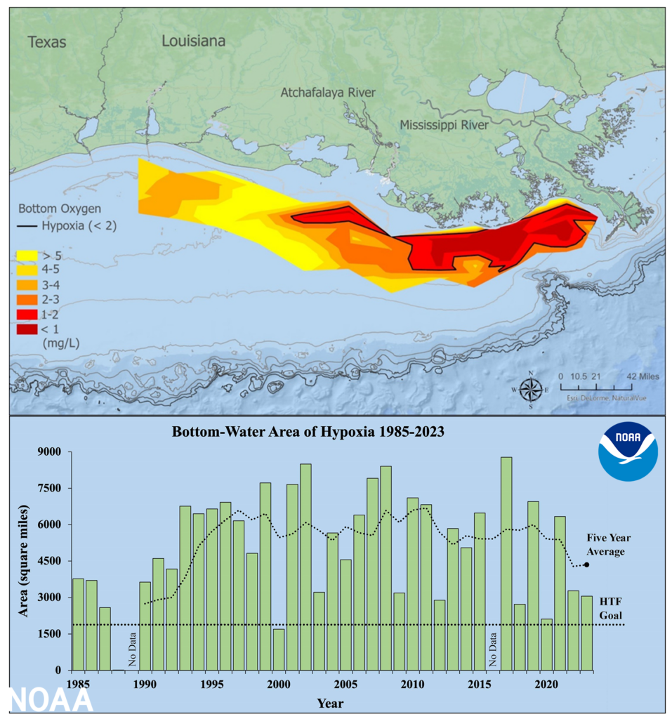
(Top) Map of measured Gulf hypoxia zone, July 23 – July 28, 2023. Red area denotes 2 mg/L of oxygen or lower, the level which is considered hypoxic, at the bottom of the seafloor. (Bottom) Long-term measured size of the hypoxic zone (green bars) measured during the ship surveys since 1985, including the target goal established by the Mississippi River/Gulf of Mexico Watershed Nutrient Task Force and the 5-year average measured size (black dashed lines). (Image credit: LUMCON/LSU/NOAA)
Excess nutrients stimulate algal growth
Each year, excess nutrients from cities, farms and other sources in upland watersheds drain into the Gulf and stimulate algal growth during the spring and summer. The algae eventually die, sink and decompose. Throughout this process, aerobic bacteria decay the algae and consume the oxygen. The resulting low oxygen levels near the bottom are insufficient to support most marine life, rendering the habitat unusable and forcing species to move to other areas to survive.
Exposure to hypoxic waters has been found to alter fish diets, growth rates, reproductionoffsite link, habitat use and availability of commercially harvested species like offsite linkshrimp. For the past two years, scientists from North Carolina State University and NOAA Fisheries have been using an experimental modeloffsite link to better forecast shrimp distribution relative to the hypoxic zone. NOAA has also been continuing to work in collaboration with States to develop new tools to forecast runoff riskoffsite link, which help limit nutrient runoff to waterways by identifying the optimal times for fertilizer application within these and other watersheds.
Investments in understanding and addressing hypoxia
The Hypoxia Task Force is accelerating progress in reducing excess nutrients in the Mississippi/Atchafalaya River Basin by promoting collaboration among federal partners, states, farmers and other stakeholders.
“Every year the dead zone in the Gulf of Mexico threatens clean water that provides essential habitat and supports economic opportunity for local communities,” said Environmental Protection Agency (EPA) Assistance Administrator for Water Radhika Fox. “At EPA, we are committed to reducing the size of the dead zone working with the states and our local partners. Through President Biden’s Bipartisan Infrastructure Law, EPA is investing $60 million over five years in work the Hypoxia Task Force and its partners are doing to reduce excess nutrients that fuel the dead zone.”
In June 2022, the EPA announced $60 million to fund nutrient reduction efforts through the Gulf Hypoxia Program. This dedicated funding will support and advance the work of all Task Force partners to protect water quality, support fisheries, create a more stable economy and advance progress towards collective water quality goals across the Mississippi/Atchafalaya River Basin. Partners of the Task Force will now have the capacity to scale up implementation of nutrient reduction strategies while increasing climate resiliency and ensuring benefits are realized by disadvantaged communities.
“States across the Mississippi River watershed are focused on implementing their nutrient reduction strategies and we are now accelerating this innovative conservation work with the help of our ever-growing roster of highly engaged public and private partners,” said Iowa Secretary of Agriculture Mike Naig, who also serves as co-chair of the Hypoxia Task Force. “Hypoxia Task Force states are making water quality progress, but we are far from satisfied. Because everyone has an important role to play in improving water quality, we remain very motivated to expand this critical implementation work on rural, suburban and urban landscapes in the years and decades ahead.”
In addition to its annual hypoxia forecast and survey, NOAA supports efforts to develop monitoring technologies to understand and map the dead zone, as well as to study the impacts of hypoxia on fish and fisheries in the Gulf of Mexico and elsewhere through its Coastal Hypoxia Research, Ocean Technology Transition, Uncrewed Systems and Hypoxia Watch Programs. Furthermore, NOAA continues to partner with and support the Northern Gulf Instituteoffsite link to deliver technical assistance, observation and monitoring capabilities, and coordination across federal, state, academic and private sector scientists.